DATA WELDER 170503M
3-Dimensional Precision Site & Satellite Finder
INOGON with SILVA 80 Compass
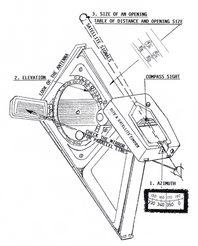 FIND THE AZIMUTH
Adjust the SILVA 80 to align
horizontal with the INOGON. Read the azimuth on the lower bolder scale. The picture is showing 346 degrees.
FIND THE ELEVATION
Set the elevation by using the movable scale to the right of zero. Align the setting with zero on the fixed upper scale. See instruction for INOGON under "High Precision
Accuracy" how to set a 10th of a degree. Lock the scale by pressing in the black knob. (Unlock it from the rear side). Raise the Finder until you see parallel lines in the mirror. The front of the Inogon will
represent the "look" of the satellite dish.
FIND THE SATELLITE SIGNALS
The incoming signals from the satellite should be viewed in the Compass Sight on top of the compass. Any obstacle for the signals will appear in the sight.
DETERMINE THE SIZE OF AN OPENING FOR THE SIGNALS
Estimate or measure the distance to the narrow opening you are going to determinate. Read the "Table of
distance and opening size" on top of the INOGON. For example: You estimate you are at least 16 meters (53 feet) from the narrow passage. If you can see through the opening with the Compass Sight you know that the
size of the opening is larger than 1.2 meters (4 feet).
<< BACK
 |